Part 4.
Western European archaeology confirms our reconstruction, likewise mediaeval cartography and geography.
Chapter 13.
Surviving mediaeval geographical world maps do not contradict our reconstruction.
1. Our analysis of the maps collected in the fundamental atlas entitled “The Art of Cartography”.
We have used the fundamental atlas of mediaeval geographical maps entitled “Kartenkunst” ([1160]) and published in 1994 as a German translation of an English publication. The atlas has a large format and contains high quality colour reproductions of maps accompanied by comments. The value of the Atlas is all the greater that the majority of ancient maps collected therein are unique, stored in various archives, libraries and special departments of European and Asian museums.
The originals of old maps are difficult to access for scientific research, and their publication in the Atlas is most timely indeed. The edition is of superb quality; however, the publishers were regarding ancient maps as works of art rather than scientific material. This is why they haven’t included close-ins of poorly legible fragments of certain maps. Some such inscriptions are semi-obliterated or faded, and others are set in a tiny script.
We consider it an absolute necessity to publish a complete atlas with all the ancient geographical maps available to date, with obligatory magnification of all the poorly legible, faded and semi-obliterated fragments. This is a formidable publishing task, granted – and yet such a publication would be of tremendous assistance for the reconstruction of the veracious mediaeval history.
Let us emphasise once again that all surviving maps need to be published – not individual samples, as it is customary nowadays. It would be desirable to evade a critical selection of maps by editors before publication.
All of the above notwithstanding, the atlas ([1160]) is doubtlessly of great interest to us in our research. It contains several dozen mediaeval maps, and this amount is already sufficient for making definite conclusions. We have only selected world maps of good legibility from the atlas ([1160]), as well as the maps of Europe, the Mediterranean and Asia. The maps of Africa and America do not interest us presently.
The table reproduced below was compiled by T. N. Fomenko after a study of the maps published in [1160]. The table information is organised as follows. First we cite the name of the map.
1) In the first column we indicate the number of a given map in our table, with its atlas number provided in parentheses.
2) The second column contains the Scaligerian dating of the map.
3) The third column tells us whether the date of a given map’s compilation is indicated anywhere on the actual map. If it is, we cite the year in question. If not, we put a dash in the corresponding cell. If the inscriptions on the map are difficult to read due to its diminutive size, small font or obliterated lettering, we put in a question mark.
4) The fourth column tells us whether the map indicates the location of Jerusalem.
5) The fifth column corresponds to the presence of Rome.
6) The sixth column indicates the presence or absence of Czar-Grad, or Constantinople.
7) The seventh column stands for the Great Wall of China and whether it can be found on the map in question.
| The table of mediaeval maps. |
| Map number |
Traditional dating |
Date on the map |
Jerusalem |
Rome |
Constantinople |
Great Wall |
| 1 (4) |
World map in oval projection. Universale descrittione di tutta la terra conosciuta fin qui. Paolo Forlani. |
| 1565. Copied from a 1546 original. |
? |
- |
- |
- |
- |
| 2 (9) |
World map in four circles. Nicolas Sansons. Les deux poles. Amsterdam. |
| 1700 |
- |
- |
- |
- |
- |
| 3 (12) |
Part of England. Warwickshyre. |
| 1612 |
- |
- |
- |
- |
- |
| 4 (13) |
Part of England. Sussex. |
| 1836 |
- |
- |
- |
- |
- |
| 5 (1.1) and (1.2) |
Fragment of the famous map entitled Tabula Peutingeriana, dated to the I century B. C. nowadays. However, we proceed to learn that the map in question is not the original, but rather a mediaeval copy dating from the alleged year 1265, no less. |
| 1265 |
- |
- |
yes |
- |
- |
| 6 (1.6) |
Map from Ptolemy's "Cartography". Germany, Gaul and Great Britain. Fragments. |
| ? |
- |
- |
- |
- |
- |
| 7 (1.9) |
The map of the world by Eratosthenes (the alleged year 220 B. C.). Reconstructed. |
| ? |
- |
- |
- |
- |
- |
| 8 (1.11) |
Ptolemy’s world map from the manuscript entitled “Codex Urbanis Graecus”. |
| XII-XIII century. |
- |
- |
- |
- |
- |
| 9 (2.1) and (2.5) |
World map. Ebstorfer, Luneburg. |
| 1399 |
? |
yes, central |
yes |
yes |
- |
| 10 (2.3) |
Circular world map. Hereford. |
| 1276 |
? |
yes, central |
? |
? |
- |
| 11 (2.4) |
Circular world map. From an English Book of Psalms. |
| XIII century |
? |
yes, central |
? |
? |
- |
| 12 (2.6) |
Circular world map. Pietro Vesconte. Mappa mundi. From the Vatican Library. |
| 1321 |
? |
? |
? |
? |
- |
| 13 (2.7) |
Circular world map. Giovanni Leardo. Mapa Mondi. Figura Mondi. Parchment. |
| 1442 |
1442 |
yes, central |
? yes? |
? yes? |
- |
| 14 (2.8) |
Map of Palestine. Made in Lübeck. |
| 1475 |
? |
yes, central |
- |
- |
- |
| 15 (2.8) |
Circular world map. Lukas Brandis, city of Lübeck. |
| 1475 |
- |
yes, central |
yes |
? - |
- |
| 16 (2.9) |
Circular world map. Hans Rust, city of Augsburg. |
| 1480 |
? |
yes, central |
yes |
? |
- |
| 17 (2.16) |
Circular world map. The Catalan Mappa Mundi. |
| 1450 |
? |
? |
? |
? |
? |
| 18 (2.16) |
World map fro the Catalan Atlas. Fragment |
| 1375 |
? |
? |
? |
? |
? |
| 19 (2.17) |
Portolano map of the Maggiolo family. The Mediterranean and its environs. |
| 1563 |
- |
? |
? |
? |
- |
| 20 (3.1) |
Nameless map. Depicts the territory from Arabia to Sumatra. |
| 1519 |
- |
- |
- |
- |
- |
| 21 (3.13) |
World map. Pierre Descelier. |
| 1550 |
1550 |
? |
? |
? |
- |
| 22 (3.15) |
World map. Anonymous, portolano. |
| XV century |
- |
? |
? |
? |
- |
| 23 (3.16) |
World map, portolano. Juan de la Cosa. |
| 1500 |
- |
? |
? |
? |
- |
| 24 (3.18) |
World map. Giovanni Contarinus. |
| 1506 |
1506 |
? |
? |
? |
- |
25 (3.19) |
World map. Johannes Ruysch, Universalior cogniti orbis tabula. Rom. |
| 1507-1508 |
? |
? |
? |
? |
- |
| 26 (3.22) |
World map. Giacomo Maggiolo |
| 1561 |
- |
? |
? |
? |
- |
| 27 (4.7) |
Map of Europe. Gerhard Mercator. |
| 1595 |
- |
- |
yes |
yes |
- |
| 28 (4.10) |
World map. Rumold Mercators Orbis terrae compendiosa descriptio quam ex magna universali Gerardi Mercatoris. |
| 1587 |
1587 |
- |
yes |
yes |
- |
| 29 (4.11) |
Map of Asia. Gerhard Mercator, Jodocus Hondius. |
1606 |
? |
- |
- |
- |
- |
| 30 (4.22) |
Map of Europe, a part of Asia and a part of Africa. Willem Blaeu, Amsterdam. |
| 1617 |
? |
? - |
yes |
yes |
- |
| 31 (4.23) |
Map of a part of Europe, Africa and the whole of Asia. Willem Blaeu. Asia noviter delineata. |
| 1617 |
- |
yes |
- |
yes |
YES |
| 32 (4.27) |
World map (rectangular). Willem Blaeu. |
| 1630 |
? |
? |
? |
? |
? - |
| 33 (4.28) |
World map as two circles. Joan Blaeu. |
| 1662 |
? |
? |
? |
? |
? |
| 34 (4.29) |
World map as four circles. Frederik de Wits Nova orbis tabula in lucem edita |
| 1675 |
? |
? |
? |
? |
YES |
| 35 (4.30) |
Rectangular world map. N. J. Visschers Nova totius terrarum orbis geographica ac hydrographical tabula. |
| 1652 |
? |
? |
? |
? |
? |
| 36 (5.3) |
Ptolemy’s world map. Francesco Berlinghieri, Florence. |
| 1482 |
? |
? |
? |
? |
- |
| 37 (5.8) |
Ptolemy’s world map, heart-shaped. |
| 1511 |
- |
- |
- |
- |
- |
| 38 (5.10) |
World map. Martin Waldseemüller, Laurent Fries. |
| 1522 |
? |
- |
- |
- |
- |
| 39 (5.13) |
World map. Battista Agnese. |
| 1543 |
- |
- |
- |
- |
- |
| 40 (5.15) |
Map of the South-East Asia. Claudia Duchetti. De Minorica insula. |
| 1570 |
? |
- |
- |
- |
- |
| 41 (5.17) |
World map as an oval projection. Paolo Forlani. Universale descrittione di tutta la terra conosciuta fin. qui. Venice. |
| 1565 |
? |
? |
? |
? |
- |
| 42 (5.18) |
World map, heart-shaped. Giovanni Cimerlino. Cosmographia universalis ab Oronto olim descripta. |
| 1566 |
? |
? |
? |
? |
- |
| 43 (5.21) |
World map. Giovanni Maria Cassini. Mappamondo del globo terraqueo. Rome. |
| 1788 |
- |
- |
- |
- |
- |
| 44 (5.35) |
World map. Oronce Fine. Nova et integra universi orbis descriptio. |
| 1531 |
- |
- |
- |
- |
- |
| 45 (6.33) |
A map of the Great Tartary. Philipp Johann von Strahlenberg. Nova descriptio geographica Tartariae magna. |
| 1730 |
1730 |
|
|
|
YES |
| 46 (6.34) |
A general map of the Russian Empire by Ivan Kirillov. |
| 1734 |
1734 |
|
|
|
YES |
| 47 (9.10) |
World map presented as a half-sphere. Pieter Goos. |
| 1666 or later |
? |
? |
? |
? |
YES |
| 48 (2.19) |
A Chinese map of Northern China, with hieroglyphs. |
| 1155 or later |
- |
- |
- |
- |
YES |
| 49 (2.20) |
A Chinese map of Northern China, with hieroglyphs. |
| 1311-1320 |
- |
- |
- |
- |
YES |
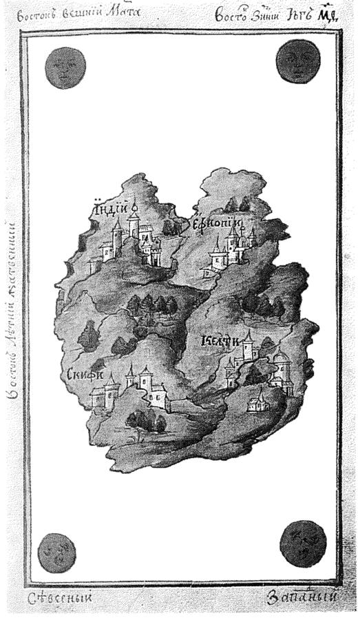
In fig, 13.1 we see the world map of Cosmas Indicopleustes manufactured in the XVII century. It refers to a total of four nations: the Scythians, the Ethiopians, India and the Celts.