Part 6.
Ancient Russia, world history and geography in mediaeval Scandinavian geographical tractates.
Chapter 21.
The meanings of the familiar modern geographical names in the Middle Ages.
The opinion of the Scandinavians.
1. How we compiled the list of geographical identifications.
Herein we shall cite the alphabetic list of geographical identifications that we have compiled as a result of our study of the mediaeval Scandinavian tractates. We have based it on the research of Y. A. Melnikova [523]. We have added some identifications of our own to the ones that she has found; all such cases are indicated accordingly.
In the resulting list, the symbol “=*=” refers to the geographical identifications and synonyms pointed out by the Scandinavian authors themselves, as well as the ones discovered and validated by Y. A. Melnikova. When we cite such identifications, we invariably indicate the page numbers of the book ([523]) where this or the other identification is mentioned or validated.
As we list the identifications of geographical names discovered by Y. A. Melnikova, in certain cases we complement her observations by identifications of our own – collations, as it were (they are marked by the symbol “=”). They are based on either a coincidence or proximity between unvocalized names, under which we understand the roots of names formed by consonants exclusively, or on collations that were discovered earlier with the application of statistical methods.
We have also accounted for the well-known cases of alternative readings of certain letters, such as:
- the Roman letter V (as well as the Roman U and Y), as well as the Greek letter Upsilon and the Slavic “Izhitsa” could be read as U or I; sometimes also as V;
- the Roman letter B and the Greek Beta could be read as V or B;
- the Roman letter C could stand for K, Ts, Ch or S.
Therefore, some of the names that might strike the modern reader as different initially are merely different ways of reading the same word.
The word “Thracia” could sound as Thracia, “Turkia” or “Turkey”. In this case, the first letter is subject to flexion, and so on.
One has to keep this in mind all the time when one reads the list of identifications as published below. It is constructed according to the following principle, which we can illustrate with an actual example. If some passage of the Scandinavian tractate tells us that Russia is the same land as Gardariki, whereas another passage identifies Gardariki as Ruzcia, and yet another claims Ruzcia to be the same as Ruzaland, as well as Ruthenna, Ruthehia or Ruthia, we record the following chain of identifications:
Russia =*= Gardariki =*= Ruzcia =*= Ruzaland =*= Ruthenna =*= Ruthenia =*= Ruthia.
Under the above we understand that in different epochs and old documents Russia, or some parts thereof, were referred to by the names in question.
Whenever a name is preceded by the word “Scandinavian” in parentheses, it emphasises the fact that this is the very form of the word used by some Scandinavian tractate or map. Scandinavians also commonly used the Latin names of the countries. Y. A. Melnikova reports the following in re the spelling of the Scandinavian geographical names, which we transcribe here in accordance with [523]:
<<Ancient Scandinavian geographical names . . . are given in transliteration, with geographical terms such as “-borg”, “-land” etc preserved>> ([523], page 7).
Let us reiterate that after the symbol “=*=” we indicate the pages of Y. A. Melnikova’s work that mention the identification in question.
2. Austria.
Austria = Austrriki. This is one of our identifications. Furthermore, Austrriki =*= Russia. We must emphasise that the latter identification is not a hypothesis of ours, but rather a direct indication contained in the Scandinavian tractates ([523], pages 87 and 89). Let us continue.
Austrriki =*= Russia =*= Gardariki =*= Rusia = Ruzcia =*= Ruzaland ([523], page 46) = The Great City ([523], page 46) =*= Austrriki ([523], pages 87 and 89).
The fact that Austria = Austrriki identifies as Russia as per the old Scandinavian maps reflect what we have already discovered earlier, namely, the fact that after the “Mongolian” conquest the area of the modern Austria was part of the Great = “Mongolian” Empiew (in the XIV-XVI century). After the decomposition of the Empire, a memory of said state has remained on the territory of its Western European fragment that we know as Austria today.
We must recollect that the German name of Austria is Österreich, which stands for “Eastern Kingdom”.
Another name of the ancient Russia, Gardariki (usually also Gard-Riki, qv in [523], for instance) is usually translated as “Land of the Cities”, “grad” translating as “city” (cf. the Slavic “grad” or “gorod”), and “riki”, as “land”, “Reich” or “kingdom”. Therefore, the “riki” compound inherent in the Western European name of Russia (Garda-Riki, similarly to Austr-Riki) apparently stands for “Reich” (Empire). On the other hand, the name “Gard” very obviously stands for “Horde” (or “Horda”), possibly also related to the Slavic word for “proud” – “gordiy”.
3. Asia = Land of the Aesir. The Azov Sea.
Asia was populated by the offspring of Shem ([523], page 32). According to the Scandinavian chronicles, “Asia was named after some woman that ruled the state that comprised the entire Eastern half of the world” ([523], page 144). Vincent refers to Asia as to the “Eastern Empire” (Imperium orientis, qv in [523], page 148).
Our hypothesis is as follows. The name Asia is derived from the name Jesus (or Iesus). This is precisely why the Scandinavians believed that Asia was populated by the Aesir – followers of Jesus, or Christians, in other words.
The Azov Sea =*= Meotis (Meotis Paludes in Scandinavian sources). This name was used in the “antiquity” as well as the Middle Ages ([523], page 211). It might be that the very name Azov is a derivative of the word Asia or the nation of the Aesir – the inhabitants of Asia, according to the Scandinavian mythology. The same applies to the toponymy of the Azov City.
4. Armenia.
Armenia = Germany. This is one of our identifications, and we shall provide a detailed account thereof in the “Africa” section, qv below. Moreover, there is another Armenia in the Caucasus. Apart from that, we know the name Great Armenia (Ermland Hinn Mikla in Scandinavian sources) = Romland = Romea =*= Byzantium.
Apparently, the name Armenia must have referred to Romania = Romea = Byzantium, as well as the Roman Empire, or the Horde (Russia) of the XIV-XVI century. After the dissolution of Empire in the XVII century, this name only survived as attached to a few of its shards – namely, Germany in Europe, qv below, and the small territory of the modern Armenia in the Caucasus.
Our explanation is simple. The decline of the Great Empire has resulted in the secession of some of its former provinces with their “Mongol” vicegerents. Each of the seceded areas declared itself independent and based its local history on the old “Mongolian” chronicles, which had encompassed the history of the whole Empire. The scale of events described therein became compressed as a result, with the claim that the events in question pertained to nothing but the tiny local territory. As a result, the formerly united history of the Empire became multiplied into several versions of the local history, which eventually ceased to resemble one another after many a copy.
The fact that the Great Armenia (Scandinavian “Ermland”) was, among other things, one of the old names borne by Germany or Prussia as parts of the Great Empire is confirmed by the following direct indication of Y. A. Melnikova. She reports the presence of “the name Ermland in the list of the Eastern Prussian lands, a tribal territory of the Varmies (one of the Prussian tribes), whereupon the Episcopacy of Ermland was founded in 1243” ([523], page 202).
Incidentally, according to Y. A. Melnikova, the mediaeval <<Saga of Hrolv the Wanderer mentions Ermland being subordinate to Russia twice: “Ermland is the residence of one of the konungs [principalilty – Y. M.] in Gardariki”>> ([523], page 202). Let us remind the reader that Gardariki was one of the names of Russia, according to the Scandinavian texts.
Apparently, the mediaeval authors often “confused” Germany and Armenia, as the modern commentators appear to believe. This is, for instance, what Y. A. Melnikova reports in reference to one of the Scandinavian texts: “Armenia is a misnomer. The list AM 227 fol indicates ‘Germania’ . . . In reality, we should see Garmania here, which is the case with the world map” ([523], page 149).
In general, it turns out that the name Ermland was often read by the mediaeval authors as “Hermland”, or simply “German land”. Y. A. Melnikova is perfectly correct to remark that the name Ermon is the same as Hermon ([523], page 203). By the way, it is believed that Mount Hermon (German Mountain) was located in the Great Armenia.
We see that certain mediaeval texts must have used the name Armenia in order to refer to the whole Great Empire, but has only survived in some of its former parts after the dissolution of the Empire in the XVII century.
Let us recollect that in CHRON1, Annex 6.5, A. T. Fomenko discovered the parallelism between the Armenian Catholicoses (whose list begins with the alleged I century A. D.) and the Roman and German Emperors of the Great = “Mongolian” Empire of the German Nation of the alleged X-XIII century A. D. with the use of altogether different methods. Therefore, we see a good concurrence between independent corollaries here.
Austrriki.
Austrriki =*= Eastern Kingdom =*= Russia (ancient Russia) – see [523], page 87.
Modern commentary is as follows: “We see the same to be the case with the ‘Guidebook’, which however calls the Asian domain Austrhaalf, or ‘Eastern Half’ . . . the term Austrriki, which is most vague indeed, may have been used in a number of different meanings – the broader one referring to all the lands to the east of Scandinavia, and the more specific standing for the ancient Russia” ([523], page 89).
It would make sense to voice the hypothesis about Aus-Tr-Riki being the Asian (Tartar) Kingdom, where Reich = Riki. Apparently, the modern Austria was once a part of the mediaeval Great = “Mongolian” Empire, known as Austrriki in general. Its centre was the ancient Russia, or the Horde.
Furthermore, Austria =*= Australia as indicated in the Scandinavian chronicles ([523], page 196). It turns out that “Australia = Austria, a duchy that seceded from Bavaria in 976” ([523], page 196). A trace of the mediaeval name Australia must have remained in the name of the European city of Austerlitz.
6. Africa. What did the name stand for in the Middle Ages? Where can we find it on the map, given that “Africa” was inhabited by many European and Asian nations?
Africa (or Affrica, as the Scandinavian sources spell it) =*= Blaland, or “Black Land” ([523], page 34). As a matter of fact, the name could have stood for “White Land” initially, if we are to consider the possibility of the name’s Slavic origin.
However, apart from the understandable “black” moniker, Africa was also referred to by a plethora of other amazing names in the Middle Ages, some of which would rather not be heard by the modern historians at all, so as to evade the unnecessary and potentially harmful questions.
6.1. Armenians used to live in Africa.
The mediaeval understanding of the term “Africa” is very interesting indeed; in some chronicles it is radically different from the modern. The readers will be much surprised to learn that Africa used to be inhabited by Armenians – still, this is precisely what the Scandinavian chronicler is telling us ([523], page 119).
And it wasn’t just the alleged ignorance of the mediaeval Scandinavian that placed Armenia in Africa (as seen from the viewpoint of the Scaligerite historians). Apparently, the “ancient” Sallust opined similarly: “The location of the Armenians in Africa is also based on a report made by Sallust” ([523], page 120). Moreover, Sallust also located the inhabitants of Mydia in Africa – a region ascribed to Central Asia nowadays ([523], page 120).
Therefore, different geographical regions were known as Africa in different epochs.
6.2. Scythia, including the Caspian North, was located in Africa.
Africa is believed to be inhabited by the descendants of the Biblical Ham ([523], page 32). Some of the mediaeval Scandinavian texts claimed that Scythia, which they also called Great Svitjod, was located in Africa. This is what the Scandinavians said in this respect: “The other third of the world is called Africa: this is where we find Serkland the Great, or Scythia, which we know as the Great Svitjod today” ([523], page 88). This mediaeval claim provokes a perfectly understandable irritated reaction from the part of the modern commentators.
This is what Y. A. Melnikova has to say about it: “In an earlier . . . tradition, when the name Serkland, with all its vagueness, was used for referring to the Northern Caspian territories [sic! – Auth.], it was believed that it bordered with Scythia in the west, also known as the Great Svitjod. The compiler of the tractate, having transferred Serkland [the Northern Caspian area – Auth.] to Africa, automatically relocated the neighbouring Scythia” ([523], page 90).
This comment makes us even more fascinated, seeing as how the mediaeval author didn’t only locate Scythia in Africa, but also the Northern Caspian area!
6.3. Our hypothesis: Africa in the Middle Ages = Tartary = Thracia = Turkey.
So what is the matter here? We shall refrain from considering ourselves confronted by yet another evidence of the mediaeval scribe’s “ignorance”, and attempt to find a rational explanation instead.
We don’t have to search for too long. Unvocalized, the name “Africa” sounds as FRK – virtually the same as “Thracia”, “Francia” etc. FRK and TRK are virtually the same word, due to the frequent flexion of F and T.
However, we already know the name TRK perfectly well. It stands for the same regions as we have already mentioned – Tartary, Turkey, France and Thracia. Hence the obvious hypothesis that in some old documents the name Africa applied to Tartary, Thracia and Turkey. In this case, the mediaeval Scandinavian author was perfectly right to locate Scythia in Africa.
Thus, the name Africa obviously altered its meaning with the course of time and drifted from one place to another on the map. As we can see, in some of the epochs it was closely associated with Scythia, or Tartary – the large state known as “Great Svitjod”, in other words. This is the reason for us to introduce another sequence of synonyms into our list of geographical identifications:
Africa = Thracia = Turkey = Turcia = Tartary = Scythia =*= Great Svitjod.
6.4. African Germany.
What other countries were considered parts of Africa in the Middle Ages? According to the Scandinavians, Germany should be counted among them. The Scandinavian geographical tractates locate Germany in Africa, dubbing it “Garamannia” ([523], pages 105 and 106). This fact alone clearly demonstrates that the name Africa was prone to relocating on the map. We shall once and for all have to perish the thought that the modern geographical names have always been attached to the same regions, ever since the deepest antiquity. Mediaeval maps clearly demonstrate this to be false.
6.5. Byzantium was believed to be part of Africa.
Furthermore, it turns out that the mediaeval Scandinavians were certain about Byzantium being part of Africa! We see it in the list of African countries as “Bizancena” ([523], page 105). It is referred to as “the most fertile land Bizancena” ([523], page 108). Y. A. Melnikova simply makes the following cautious comment in re the name “Bizancena”: “an adjective from the toponym ‘Byzacium’” ([523], page 110).
Given that, as we see, the name Africa was used for referring to large territories in Europe and Asia in certain epochs, which identifies it as Tartary = Thracia and the entire Greater Scythia in general, qv below, we get a natural explanation of the mediaeval report that Africa was populated by Armenians ([523], pages 119 and 120). The matter is that the name Armenia was sometimes used as the synonym of “Germany”, qv above in paragraph 4. As we have already mentioned, it is assumed that the mediaeval authors often “confused” the terms “Armenia” and “Germany”. Modern commentators try to correct the Scandinavians: “The reference to Armenia is erroneous. The list AM 227 fol indicates ‘Germania’ . . . in reality, we should see ‘Garmania’, as on the world map” ([523], page 149).
6.6. African Albania.
It would make sense to point out that the “early ancient” name of Africa was different – Libia, usually associated with the modern Libya. It is reported that “‘Libia’ was the early ancient name of Africa” ([523], page 210). However, even here we see vestiges of the initial European location of Africa. Libya is merely another version of the word “Alba”, which stands for “white”. And we must remember that White Russia (or Byelorussia) was one of the main Hordes of the Great = “Mongolian” Empire. The country Albania still exists on the European map as a tiny remnant of the former vast lands of the White Horde. It was only later, when the name Tartary (Africa) spread over a great amount of lands and started to include the present African continent as a result of the Great = “Mongolian” conquest, that the name Albania travelled to North Africa, eventually transforming into the modern Libya.
This hypothesis is also confirmed by the mediaeval English sources – see [517] and the table of mediaeval names that we have compiled after the book of V. I. Matouzova, which can be found in CHRON4, Chapter 15:1.5. It turns out that the Albanians were also known as “Liubene”, or Libyans.
The fact that some of the ancient texts referred to Tartary (also known as Thracia and Turkey), or even the entire Scythia, as Africa, is also indirectly confirmed by the following circumstance: apparently, some of the sources mention the existence of “three Africas” – just like there were “three Indias” in the Middle Ages. As we demonstrate above, this is most likely to be a reference to the Great = “Mongolian” Empire, or Russia, which comprised three Hordes.
The Scandinavian source reports the existence of <<three Blalands, without listing them or providing any explanations . . . the ‘World Saga’ mentions two Blalands: “There are two populated lands known as Blaland: one is in the far East, right next to the place where the sun rises; the other is in Mauritania in the West”>> ([523], page 200).
Finally, the Scandinavians claimed that Africa =*= Blaland =*= Ethiopia. This is what the ancient text is telling us: “Ethiopia, which we call Blaland” ([523], page 200). However, in this case we are confronted by an interesting question: could the name “Ethiopia” have been used for referring to Russia (the Horde) or some European or Asian territory in the Middle Ages? The answer is in the positive.
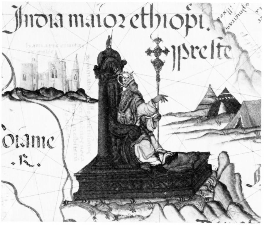
Apparently, Ethiopia was considered to be the residence of the Christian Presbyter Johannes ([1177], page 333). Moreover, the land of Presbyter Johannes was sometimes indicated on mediaeval maps as the Great Ethiopian India (India Maior Ethiopi). This is the case with the map from the atlas of Diego Homem dating from 1565 (see fig. 21.1). Therefore, we get the impression that the word “Ethiopia” was at some point the name of the ancient Russian Empire of the XIV-XVI century. As we have already demonstrated, the kingdom of Presbyter Johannes identifies as the mediaeval Russia, or the Horde = India, “faraway land”, qv in CHRON5, Chapter 8.
It is possible that the name “Ethiopia” formerly stood for “Japheth’s part”. It is also known that “Japheth’s part” (or Ethiopia) had formerly stood for the whole of Europe and a significant part of Asia.
Thus, we shouldn’t rule out the possibility that the name “Ethiopia” is a slightly corrupted version of the name “Japheth”. Let us go onward and study the mediaeval list of “African” countries further.
6.7. The African Goths. Samaria (or Sarmatia) was located in Africa.
Apparently, the Scandinavians claim that Africa was populated by the Goths. Their country is called Getulia ([523], pages 118 and 119). This is in good correspondence with our reconstruction, which claims that in different historical periods the Goths, the Hittites, the Tartars and the Turks were but different names of the same nation. The name “Africa” was the same as FRK and TRK – Turkey (or Tartary). The same Scandinavian list of African lands contains “the Trogita province” – apparently, TR-Gothia, or the Tartar (Trojan) Gothia.
Furthermore, according to the Scandinavians, Sarmatia was also located in Africa ([523], pages 118 and 119). It can be identified as either the Russian city of Samara, or the famous mediaeval Scythian Sarmatia, which was associated with Samaria as mentioned in the Bible. However, all these countries are located in Europe and Asia today – not Africa.
Let us linger on Samaria for a while. One of the countries bearing said name (Samaria or Samarium in Scandinavian sources) was located in the Middle Eastern Palestine by the Scaligerite geographers ([523], page 215). However, we have to recollect the famous mediaeval nation of the Sarmatians (Sarmathe). Historians date them to the faraway epoch preceding the IV century A. D., claiming that the Sarmatians resided to the North of the Black Sea ([523], page 215). Yet we find out that in mediaeval literature “the name [Sarmatians – Auth.] was used for referring to any nomadic tribe residing to the north of the Black Sea, later becoming an alias of the ancient Russians” ([523], page 215). Therefore, Sarmatia =*= ancient Russia in the Middle Ages.
Thus, the Scandinavian sources imply that the ancient Russia, or Sarmatia, was also located in Africa.
6.8. The true identity of the “African” Mauritania.
We all know that Mauritania used to be located in Africa – an African land known under that name exists until the present day. The reader might think that we won’t be able to find Mauritania anywhere else, apart from the modern Africa. But let us quote the Scandinavian chronicle, which gives us a list of African countries wherein Mauritania is divided in two parts – “Mauritaniam Sitifensem” and “Mauritanium Tingitanam” ([523], page 90). We see direct references to Scythian Mauritania and Mauritania of the Tanguts (Tan-Goths).
Therefore, the first Mauritania was in Scythia, whereas the second appears to have been located in the area populated by the Don Goths (Tan-Guts), as mentioned above. The name “Tanguts” eventually migrated to the East of the map; the reader can spot it right next to the Chinese border in the maps of the XVIII century, for example, as described in Part 1.
6.9. How many African lands were located in Europe and Asia initially?
Before saying our farewells to Africa, it would be very edifying to count the percentage of “African lands” discovered in Europe and in Asia as per the Scandinavian texts, and to what extent the name “Africa” was associated with the Great = “Mongolian” Empire. The answer is as follows. The Scandinavian world map that we reproduced above, in fig. 11.6, for instance, lists 11 countries or regions as African ([523], page 108): Libya, Circatyrene, the kingdom of Pentapollis, the Trogita Province, the lands of Bizancena, Garamania and Getulia, Isle of Gaullo, Numidia, Mauritania (three lands bearing said name) and Ethiopia. Seven provinces out of eleven can be identified more or less definitely as European and Asian countries. That amounts to two thirds. It is possible that a detailed analysis of descriptions and comparisons of the other “African nations” will add a number of European regions to that list. At any rate, this is to be expected in the following cases:
Numidia (possibly, N-Mydia?),
Pentapolis (simply “Five Cities”),
Circatyrene – CRCS-TRN, or Royal Tyrene (Tirana) – or, alternatively, “Royal Franks”. Let us remind the reader that the city of Tirana still exists in the Balkans as the capital of Albania. Apart from that, “tyrant” was a mediaeval Greek title of a ruler – therefore, “Tyrene” must have simply stood for “Tyrant’s City”, or “capital”.
Taking the three names as mentioned above in consideration, we can locate ten names out of eleven in Europe. It would be expedient to study all the other maps as reproduced in [523] from this point of view. We haven’t done it so far.
7. Blaland = “Black Land” or Babylon.
Blaland translates as “Black Land” =*= Africa ([523], page 34). Above we have demonstrated that in the Middle Ages Africa was the name of large parts of Europe and Asia. The reader might want to use the following counter-argumentation: “But wasn’t Africa known as Bla-Land, or Black Land, after all? What ‘Black Lands’ are there in Europe, anyway?”
First of all, let us recollect the Black Sea. It is right where we need it and it washes the coasts of Tartary = Turkey = Thracia = Scythia, or Africa, in other words (TRK/FRK unvocalized).
Also, the mediaeval English used to call the Balkan Wlachia “Blachi” and “Black” – black, in other words, qv in [517] and in the table of geographical identifications that we have compiled after the book of V. I. Matouzova and reproduced in CHRON4, Chapter 15:1.5. In order to leave us no doubts about the identity of the Wlachians, they were also called Turks in mediaeval England ([517]).
Finally, there is the European country known as Montenegro – the name translates as “Black Mountain” (cf. with the name of the Russian city Chernigov, which means virtually the same thing).
Therefore, many areas of Europe have the word “Black” as part of their name. This brings us to the following question: when did the European concept of “Black Africa” evolve (one of a continent populated by dark-skinned people)? As we have demonstrated above, this appears to have happened in the following manner. Firstly, the Great = “Mongolian” invasion carried many of the Russian (and European in general) names all across the world. They ended up in modern Africa as well. Furthermore, when the Scaligerite historians started to write the “new history of humanity”, they must have thought that “Black Africa” was the name of all the lands populated by black (or dark-skinned) people, which is why some part of the European map was relocated from Europe to the African continent as we understand it today. This was either a mistake or a premeditated act of disinformation.
Let us now consider the ancient Babylon ([523], page 79). Today it is believed to have been located in Mesopotamia, whereas the New Babylon usually identified as Cairo in modern Egypt ([523], page 79). According to Melnikova, “Babylon is mentioned twice – in the list of toponyms associated with the Middle East and Mesopotamia and also right next to Egypt. In the latter case the city in question is more likely to be identified as the New Babylon, or Cairo” ([523], page 110).
8. The Great Svitjod (Saint) = Russia = Scythia.
According to the Scandinavian authors, the Great Svitjod includes all of Russia – in other words, Russia =*= Scythia =*= Gardariki ([523], page 65) =*= Russ =*= Rusia =*= Ruzcia =*= Rusland =*= Ruzaland ([523], page 226) =*= Gardar ([523], page 46) =*= the Great City (Velikiy Grad/Gorod in Slavic – see [523], page 46) =*= Austrriki ([523], pages 87 and 89). We can add the abovementioned collations to these Scandinavian identifications, namely Russia (the Horde) = Austria = Africa = Thracia = Tartary = Turkey.
Occasionally, the whole of the Great Svitjod (The Great and Holy, or “Velikaya Svyataya”?) is identified as Scythia and Russia. This is what Y. A. Melnikova reports, for instance: <<‘Svitjod hinn mikla’, or the Great Svitjod. The origins of the toponym can be traced to the creation of the scientific legend [obviously treated with scepticism by the learned historians – Auth.] about the Aesir, or the natives of Asia (Troy) being the forefathers of the Scandinavians [see CHRON5, Chapter 11:3 - Auth.]. The term “Great” was used to distinguish between this great kingdom, populated by the ancestors of the Scandinavians, who were led to the North by Odin, and the Lesser Svitjod, or Sweden. The toponym must have been affected by the Western European name Great Scythia, directly identified as the Great Svitjod in the “Descriptions of the Earth” (II and III), as well as other tractates>> ([523], page 217). The Great Svitjod is populated by the Magon nation.
Therefore, we can see that Magon, son of Japheth and grandson of Noah, lived in the Great Svitjod =*= Russia =*= Scythia ([523], page 65).
It is very interesting indeed that, according to the mediaeval Scandinavian authors, their land (Scandinavia) was populated by the Russians, or the inhabitants of the Great Svitjod (see CHRON5, Chapter 11:3). In turn, Russia =*= Great Svitjod (Great and Holy?) is reported to have been populated by the Turkic peoples (ibid).
Furthermore, the Scandinavians clearly tell us that the Great Svitjod = Scythia of the XIV-XV century was the land of Magog, or the land of the Mongols. This is the ancient text in question: “The easternmost part of Europe is Scythia, which we call Great Svitjod. Philip the Apostle used to preach there. Gardariki [Russia, qv below – Auth.] is where one finds Palteskja [Polotsk, qv below – Auth.] and Canguarde [Kiev, qv below – Auth.]. This was the first residence of Magog, son of Japheth, grandson of Noah. This land [Gardariki – Auth.] is also where one finds Kurland and Kirjaland, Samland [Samara, or Samarqand? – Auth.], Ermland . . . Thracia is the same as Grikland. This is where Thiras, son of Japheth, grandson of Noah, lived initially. His descendants are known as the Turks” ([523], page 96).
All these mediaeval data are telling us that the names as listed above date from the XIII-XIV century of the new era the earliest. As we have pointed out above, the name Great Svitjod is a possible derivative of “The Great and Holy”, or “God’s Land”. We thus learn another ancient name of Russia, or the Horde, in the XIV-XVI century.